Trekking Maps 20240124-1.0.209
Free Version
Publisher Description
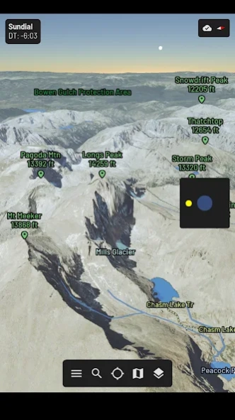
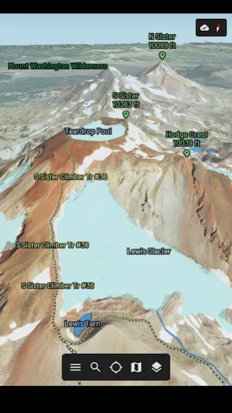
3D SUPPORT
• High Performance 3D Maps
• Worldwide 3D Terrain
• 3D Printing Support
• Integrated Flight Simulator
• Embed 3D Models in Websites
MAP STYLES
• Aerial Imagery (Lower 48 States)
• Relief Shading
• Slope Angle Shading
• Seasonal/Day/Night Shading
LOCATION
• My Location
• My View Peak Finder
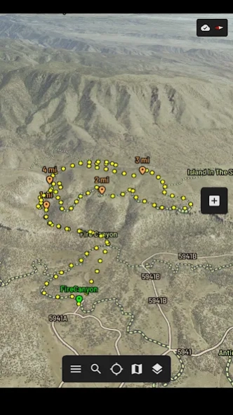
• GPS Tracks
INFORMATION
• Offline Support
• Sunrise/Sunset Times
• Sundial to Reposition the Sun
• Measure Distance/Elevation/Altitude
About Trekking Maps
Trekking Maps is a free app for Android published in the Geography list of apps, part of Education.
The company that develops Trekking Maps is 3DGE Software, LLC. The latest version released by its developer is 20240124-1.0.209.
To install Trekking Maps on your Android device, just click the green Continue To App button above to start the installation process. The app is listed on our website since 2024-01-24 and was downloaded 3 times. We have already checked if the download link is safe, however for your own protection we recommend that you scan the downloaded app with your antivirus. Your antivirus may detect the Trekking Maps as malware as malware if the download link to com.EDGESoftware.TREK is broken.
How to install Trekking Maps on your Android device:
- Click on the Continue To App button on our website. This will redirect you to Google Play.
- Once the Trekking Maps is shown in the Google Play listing of your Android device, you can start its download and installation. Tap on the Install button located below the search bar and to the right of the app icon.
- A pop-up window with the permissions required by Trekking Maps will be shown. Click on Accept to continue the process.
- Trekking Maps will be downloaded onto your device, displaying a progress. Once the download completes, the installation will start and you'll get a notification after the installation is finished.
Program Details
General |
|
|---|---|
| Publisher | 3DGE Software, LLC |
| Released Date | 2024-01-24 |
| Languages | English |
Category |
|
|---|---|
| Category | Education |
| Subcategory | Geography |
System requirements |
|
|---|---|
| Operating systems | android |
Download information |
|
|---|---|
| File size | |
| Total downloads | 3 |
Pricing |
|
|---|---|
| License model | Free |
| Price | N/A |
Version History
version 20240124-1.0.209
posted on 2024-01-24
1/24/2024
• Added boot icon
• Fixed a slope angle calculation
9/16/2023
• Added support for Android 13
• Added Aerial UT 2021 Map Style
• Updated OpenStreetMap Database
• Fixed a network hang bug
11/17/2022
• Added track grade to track details
• Added an Elevation Profile window under track details
• Added fullscreen option under settings
• Optimized graphics rendering performance
version 20230916-1.0.207
posted on 2023-09-16
9/16/2023
• Added support for Android 13
• Added Aerial UT 2021 Map Style
• Updated OpenStreetMap Database
• Fixed a network hang bug
11/17/2022
• Added track grade to track details
• Added an Elevation Profile window under track details
• Added fullscreen option under settings
• Optimized graphics rendering performance
version 20221117-1.0.201
posted on 2022-11-19
11/17/2022
• Added track grade to track details
• Added an Elevation Profile window under track details
• Added fullscreen option under settings
• Optimized graphics rendering performance
11/10/2022
• Added ascent/descent/elevation profile to track details
• Fixed a sky rendering bug
• Tweak railway colors
• Tweak UI widget spacing and borders
• Internal redesign of UI event handling
10/14/2022
• Add coarse location support (Android 12)
• Fix database initialization issue
version 20220427-1.0.162
posted on 2022-04-30
4/30/2022
. Updated OpenStreetMap database
. Added national parks/forests/protected areas
. Added villages/hamlets/states/countries
. Added oceans/seas
. Added capital star marker
. Added line weight setting
. Added flight computer placeholder
. Fixed abbreviations for proper names
. Improve line drawing when zoomed out
. Optimize performance
version 20220322-1.0.149
posted on 2022-03-23
3/23/2022
. Improved line scaling when zoomed out
. Draw more OpenStreetMap features when zoomed out
. Optimized line/polygon rendering performance
. Fixed corrupted polygon rendering for some lakes
. Fixed line cap on building outlines
. Reduced acceleration/deceleration rates on flight simulator
. Fixed stuck accelerator/decelerator on flight simulator
3/3/2022
. Replaced flight simulator plane model
. Added a virtual joystick for flight simulator
. Fixed a bad HTTP link
version 20220303-1.0.139
posted on 2022-03-03
3/3/2022
. Replaced flight simulator plane model
. Added a virtual joystick for flight simulator
. Fixed a bad HTTP link
1/26/2022
. Improve sky gradient shader
. Make roll/pitch rates proportional to speed
. Added HUD panel for flight simulator
1/23/2022
. Added labels to flight simulator
. Render flight simulator in full screen
1/14/2022
. Flight simulation alpha testing
version 20211207-1.0.124
posted on 2021-12-07
12/07/2021
. Add fade label animation
. Add labels for shops, amenities, etc.
. Add labels for highways and exits
. Add labels for ski lifts
. Tune label placement performance
. Increase font weight
. Improve capitalization and abbreviations of labels
. Add buildings
. Updated OpenStreetMap database
11/08/2021
. Improve label visibility
. Added tertiary line colors
11/01/2021
. Improved label placement
version 20211108-1.0.122
posted on 2021-11-10
11/08/2021
. Improve label visibility
. Added tertiary line colors
11/01/2021
. Improved label placement
10/19/2021
. Improved label placement
9/28/2021
. Redesign Scoped Storage (e.g. Save As/Import)
. Optimize labeling performance
. Fixed issue with sunrise/sunset times
9/8/2021
. Redesign line style
. Redesign line drawing algorithms
. Optimize memory manager
. Removed storage permissions
version 20211019-1.0.119
posted on 2021-10-20
10/19/2021
. Improved label placement
9/28/2021
. Redesign Scoped Storage (e.g. Save As/Import)
. Optimize labeling performance
. Fixed issue with sunrise/sunset times
9/8/2021
. Redesign line style
. Redesign line drawing algorithms
. Optimize memory manager
. Removed storage permissions
8/22/2021
. Disable debug setting causing performance issue
8/21/2021
. Fixed a Scoped Storage bug
version 20210928-1.0.117
posted on 2021-09-28
9/28/2021
. Redesign Scoped Storage (e.g. Save As/Import)
. Optimize labeling performance
. Fixed issue with sunrise/sunset times
9/8/2021
. Redesign line style
. Redesign line drawing algorithms
. Optimize memory manager
. Removed storage permissions
8/22/2021
. Disable debug setting causing performance issue
8/21/2021
. Fixed a Scoped Storage bug
version 20210908-1.0.114
posted on 2021-09-10
9/8/2021
. Redesign line style
. Redesign line drawing algorithms
. Optimize memory manager
. Removed storage permissions
8/22/2021
. Disable debug setting causing performance issue
8/21/2021
. Fixed a Scoped Storage bug
8/16/2021
. Redesigned data caching to use SQLite
. Added Scoped Storage for Android 11
You will receive a prompt with further details about Scoped Storage to grant access to a working directory for 3D printed models and GPX tracks.
version 20210822-1.0.107
posted on 2021-08-22
8/22/2021
. Disable debug setting causing performance issue
8/21/2021
. Fixed a Scoped Storage bug
8/16/2021
. Redesigned data caching to use SQLite
. Added Scoped Storage for Android 11
You will receive a prompt with further details about Scoped Storage to grant access to a working directory for 3D printed models and GPX tracks.
6/29/2021
. Simulate atmosphere (Sunrise/Sunset/Nighttime)
. Add Sundial to adjust Sun position
version 20210821-1.0.106
posted on 2021-08-21
8/21/2021
. Fixed a Scoped Storage bug
8/16/2021
. Redesigned data caching to use SQLite
. Added Scoped Storage for Android 11
You will receive a prompt with further details about Scoped Storage to grant access to a working directory for 3D printed models and GPX tracks.
6/29/2021
. Simulate atmosphere (Sunrise/Sunset/Nighttime)
. Add Sundial to adjust Sun position
4/26/2021
. Upgrade server for aerial, terrain and blue sky data
. Optimize networking performance
version 20210816-1.0.105
posted on 2021-08-17
8/16/2021
. Redesigned data caching to use SQLite
. Added Scoped Storage for Android 11
You will receive a prompt with further details about Scoped Storage to grant access to a working directory for 3D printed models and GPX tracks.
6/29/2021
. Simulate atmosphere (Sunrise/Sunset/Nighttime)
. Add Sundial to adjust Sun position
4/26/2021
. Upgrade server for aerial, terrain and blue sky data
. Optimize networking performance
4/13/2021
. Fix a crash on an Android TV device
version 20210629-1.0.98
posted on 2021-06-29
6/29/2021
. Simulate atmosphere (Sunrise/Sunset/Nighttime)
. Add Sundial to adjust Sun position
4/26/2021
. Upgrade server for aerial, terrain and blue sky data
. Optimize networking performance
4/13/2021
. Fix a crash on an Android TV device
4/12/2021
. Optimize CPU performance
4/5/2021
. Optimize OpenStreetMap server
. Optimize networking performance
. Optimize graphics memory performance
version 20210426-1.0.92
posted on 2021-04-26
4/26/2021
. Upgrade server for aerial, terrain and blue sky data
. Optimize networking performance
4/13/2021
. Fix a crash on an Android TV device
4/12/2021
. Optimize CPU performance
4/5/2021
. Optimize OpenStreetMap server
. Optimize networking performance
. Optimize graphics memory performance
2/27/2021
. Upgrade OpenStreetMap server database
. Update The CORE Act data
. Preliminary support for worldwide Roads & Labels
. Depreciate Satellite map style from MapTiler
version 20210413-1.0.88
posted on 2021-04-13
4/13/2021
. Fix a crash on an Android TV device
4/12/2021
. Optimize CPU performance
4/5/2021
. Optimize OpenStreetMap server
. Optimize networking performance
. Optimize graphics memory performance
2/27/2021
. Upgrade OpenStreetMap server database
. Update The CORE Act data
. Preliminary support for worldwide Roads & Labels
. Depreciate Satellite map style from MapTiler
version 20210227-1.0.77
posted on 2021-02-28
2/27/2020
. Upgrade OpenStreetMap server database
. Update The CORE Act data
. Preliminary support for worldwide Roads & Labels
. Depreciate Satellite map style from MapTiler
12/30/2020
. Added Satellite map style from MapTiler
. Removed the background permission location
12/21/2020
. Upgraded search engine
. Fixed a bug with 3D printed wall thickness with steep slopes
version 20201230-1.0.70
posted on 2020-12-31
12/30/2020
. Added Satellite map style from MapTiler
. Removed the background permission location
12/21/2020
. Upgraded search engine
. Fixed a bug with 3D printed wall thickness with steep slopes
10/2/2020
. Fixed a bug with 3D printed model height (scale off by 1.4x)
. Improve texture quality of 3D printed models
. Added border/base to webpage models
. Made 3D printed model cross braces optional
version 20201221-1.0.68
posted on 2020-12-21
12/21/2020
. Upgraded search engine
. Fixed a bug with 3D printed wall thickness with steep slopes
10/2/2020
. Fixed a bug with 3D printed model height (scale off by 1.4x)
. Improve texture quality of 3D printed models
. Added border/base to webpage models
. Made 3D printed model cross braces optional
version 20201002-1.0.64
posted on 2020-10-02
10/2/2020
. Fixed a bug with 3D printed model height (scale off by 1.4x)
. Improve texture quality of 3D printed models
. Added border/base to webpage models
. Made 3D printed model cross braces optional
9/3/2020
. Added low memory handler
. Added model scale to info panel
. Added model options to model selection
version 20200903-1.0.60
posted on 2020-09-12
9/3/2020
. Added low memory handler
. Added model scale to info panel
. Added model options to model selection
8/31/2020
. Added anti-aliased line rendering
. Added file path when exporting data
. Improved viewing and editing of GPX files
. Android Location Permission is now optional
. App size reduced via Android App Bundles
version 20200831-1.0.58
posted on 2020-08-31
8/31/2020
. Added anti-aliased line rendering
. Added file path when exporting data
. Improved viewing and editing of GPX files
. Android Location Permission is now optional
. App size reduced via Android App Bundles
8/4/2020
. Redesign UI
. Added GPX metadata editing
version 20200804-1.0.47
posted on 2020-08-05
8/4/2020
. Redesign UI
. Added GPX metadata editing
7/25/2020
. Added labels for GPX track mile markers
. Added GPX waypoints, routes and metadata
. Added track loop notification
. Improved ray casting
version 20200725-1.0.42
posted on 2020-07-26
7/25/2020
. Added labels for GPX track mile markers
. Added GPX waypoints, routes and metadata
. Added track loop notification
. Improved ray casting
7/4/2020
. Fixed holes in 3D terrain (outside lower 48 states)
. Fixed issue causing roads and labels to flicker
. Fixed collision detection issue causing camera to jump
. GPS no longer disabled by panning
version 20200704-1.0.34
posted on 2020-07-04
7/4/2020
. Fixed holes in 3D terrain (outside lower 48 states)
. Fixed issue causing roads and labels to flicker
. Fixed collision detection issue causing camera to jump
. GPS no longer disabled by panning
6/17/2020
. Added Vulkan feature flag
. Converted from fullscreen mode to windowed mode
. Should fix issue with Samsung soft keyboard
. Allows user to see status bar (e.g. clock/gps/etc)
. Allows user to easily access navigation bar (e.g. home/back buttons)
version 20200617-1.0.28
posted on 2020-06-18
6/17/2020
. Added Vulkan feature flag
. Converted from fullscreen mode to windowed mode
. Should fix issue with Samsung soft keyboard
. Allows user to see status bar (e.g. clock/gps/etc)
. Allows user to easily access navigation bar (e.g. home/back buttons)
6/14/2020
. Added info panel to select model screen
. Search box now accepts lat,lon pair
. Moved about page information to website
version 20200612-1.0.23
posted on 2020-06-13
6/12/2020
. Fix X3D model coordinates
. Increase model sample count
. Remove temporary model files
. Fix PNG issue with Blue Marble and Citylights textures
6/02/2020
. Added day/night rendering for Blue Marble map style
. Added sunrise/sunset times when GPS is active
5/23/2020
. Added model exporting for 3D printing
. http://www.3dgesoftware.com/3dprinting
version 20200607-1.0.22
posted on 2020-06-08
6/07/2020
. Increase texture resolution for 3D prints
. Change model orientation to match Shapeways
. Added Webpage export type
. Remove X3D and PNG tmp files
. Added user guide for webpage/blender
. http://www.3dgesoftware.com/webpage
. http://www.3dgesoftware.com/blender
6/02/2020
. Added day/night rendering for Blue Marble map style
. Added sunrise/sunset times when GPS is active
5/23/2020
. Added model exporting for 3D printing
. http://www.3dgesoftware.com/3dprinting
version 20200602-1.0.20
posted on 2020-06-02
6/02/2020
. Added day/night rendering for Blue Marble map style
. Added sunrise/sunset times when GPS is active
5/23/2020
. Added model exporting for 3D printing
. http://www.3dgesoftware.com/3dprinting
5/05/2020
. Added ripple center marker
. Added ripple altitude
. Fixed coordinate transformation bug
. Fixed a scene clipping bug
version 20200523-1.0.19
posted on 2020-05-24
5/23/2020
. Added model exporting for 3D printing
. http://www.3dgesoftware.com/3dprinting
5/05/2020
. Added ripple center marker
. Added ripple altitude
. Fixed coordinate transformation bug
. Fixed a scene clipping bug
4/22/2020
. Today is Earth Day!
. Added Earth ellipsoid model
. Fixed terrain shading issue outside lower 48 states
. Fixed unsupported color format on older phones
. Fixed a crash and memory leak with GPS tracks
version 20200505-1.0.12
posted on 2020-05-06
5/05/2020
. Added ripple center marker
. Added ripple altitude
. Fixed coordinate transformation bug
. Fixed a scene clipping bug
4/22/2020
. Today is Earth Day!
. Added Earth ellipsoid model
. Fixed terrain shading issue outside lower 48 states
. Fixed unsupported color format on older phones
. Fixed a crash and memory leak with GPS tracks
version 20200422-1.0.5
posted on 2020-04-22
4/22/2020
. Today is Earth Day!
. Added Earth ellipsoid model
. Fixed terrain shading issue outside lower 48 states
. Fixed unsupported color format on older phones
. Fixed a crash and memory leak with GPS tracks
3/29/2020
. Added ASTERv3 worldwide terrain
. For shaded relief, slope angle and blue marble styles
. Increased near/far zoom ranges
. Rearranged My Tracks and The CORE Act layers
3/21/2020
. Fixed label flickering when zooming
. Optimize line/polygon rendering
version 20200329-1.0.4
posted on 2020-04-08
3/29/2020
. Added ASTERv3 worldwide terrain
. For shaded relief, slope angle and blue marble styles
. Increased near/far zoom ranges
. Rearranged My Tracks and The CORE Act layers
3/21/2020
. Fixed label flickering when zooming
. Optimize line/polygon rendering
3/2/2020
. Vulkan graphics supported for improved performance
. OpenGL graphics depreciated for older devices
1/22/2020
. Added a new layer for The CORE Act
9/25/2019
. Added joystick support
version 20200321.1
posted on 2020-03-22
3/21/2020
. Fixed label flickering when zooming
. Optimize line/polygon rendering
3/2/2020
. Vulkan graphics supported for improved performance
. OpenGL graphics depreciated for older devices
1/22/2020
. Added a new layer for The CORE Act
9/25/2019
. Added joystick support
9/24/2019
. Fixed a bug with recording GPX tracks
8/17/2019
. Trekking Maps is now FREE
. Removed In-App purchases
version 20200302
posted on 2020-03-02
3/2/2020
. Vulkan graphics supported for improved performance
. OpenGL graphics depreciated for older devices
1/22/2020
. Added a new layer for The CORE Act
9/25/2019
. Added joystick support
9/24/2019
. Fixed a bug with recording GPX tracks
8/17/2019
. Trekking Maps is now FREE
. Removed In-App purchases
version 20200122
posted on 2020-01-23
1/22/2020
. Added a new layer for The CORE Act
9/25/2019
. Added joystick support
9/24/2019
. Fixed a bug with recording GPX tracks
8/17/2019
. Trekking Maps is now FREE
. Removed In-App purchases
version 20190925
posted on 2019-09-26
9/25/2019
. Added joystick support
. Left Axis > Pan
. Right Axis > Tilt/Rotate
. Triggers > Zoom
9/24/2019
. Fixed a bug with recording GPX tracks
8/17/2019
. Trekking Maps is now FREE
. Removed In-App purchases
